(Before I get into
the whole temple business, the photo above is of a labyrinth that we
encountered on our very first day out. After
scoping out the inside of the Ta Pinu Shrine, I promptly went back out and
walked this labyrinth before everyone else came out of the church. What a magical omen for the start to a great
trip!)
I am utterly
fascinated by megalithic structures.
They are found all over the world, on land and also off shores when their
locations were flooded by rising sea levels after the last Ice Age. Dating these sites is difficult because back
then there were no written records, and stone cannot be carbon dated. Archaeologists do the best that they can with
that. I suspect, but cannot prove that
most sites are older than researchers think that they are.
I have been to
many megalithic sites, including Stonehenge, Avebury, Carnac, Gobekli Tepe, and
all over Peru to name a few. When I
learned about the megalithic history of Malta, I had to go and see for myself. If you are interested, I encourage you to do
some research. An excellent book is “Malta
& Gozo, a Megalithic Journey “ by Neil McDonald.
Those ancient
people were very in tune with the cosmos, so most of these sites were aligned with
solstices and equinoxes. Certainly,
ceremonies were performed at these times of year, but what they consisted of,
we do not know. The sun and moon,
planets and stars were magical beings to them.
The society’s “shaman” was in charge of these aspects of community life.
According to archaeologists,
the Temple Period here goes from 4100 B.C. to 2500 B.C. at which time the
islands were mysteriously abandoned. There
were indications of human presence on Malta going back at least to 8000 B. C. and
even earlier, so people were there before the temples were built.
There are about
35 locations where the temples are still mostly intact or partially intact. There are an additional 30 locations where
some remains have been documented. Most
of this destruction happened when areas were farmed or houses were built and the temples were destroyed
in the process. It is also important to
note that through the many thousands of years after the Temple Period came to
an end, all of these locations were gradually covered over with soil by the natural processes
of wind and weather.
Our group
visited 4 of the most important temples.
The general layout for each consists of a central corridor with 2 or 3
pairs of rooms on each side leading back to the sacred area, or Holy of Holies. Kind of like a four leaf clover
design. I used my pendulum to test each
temple, and found all of them to be highly energized with the most energy at
the very back. Below is a diagram of the Ggantija Temples

The alignments
of the central corridor are a very interesting matter. From the
back of the temple looking down the corridor and out the very front, all of
them are pointing in some variation either southwest or southeast. In
her book, “Sirius the Star of the Maltese Temples”, Lenie Reedijk lays out the proof
that starting in 9150 B. C., each temple was aligned with either the rising or
setting of the star Sirius. That
explains where the various temples were situated, to take advantage of this bi-yearly
event. This also puts the Temple Period
back 5000 years! Of course, there is
more to this, but you have to read her book to get more of this fascinating
story.
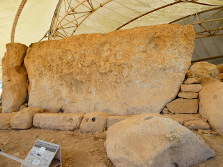
So here are
some photos of the temples. First there
are the Ggantija Temples, the only ones not covered by a canopy.
Next, the
Tarxien Temples. These are the best preserved,
and my favorite energetically.
On the next to the
last day, we first visited the Hagar Qim Temple.
Lastly, the Mnajdra
Temples. Both this one and Hagar Qim are
situated close together and on a rugged and scenic rocky slope leading down to the
sea and a view of tiny Filfla Island.
Here is Filfla Island.
So this is the big post. More photos to come.


